|
Custom Solutions |
|
|
Our clients work with complex data and processes which demand specific software that extends beyond typical off-the-shelf applications. Baird Software develops intuitive software and system solutions to meet these specific needs. These custom software applications integrate relevant numerical models and remote sensing platforms within a GIS framework. |
|
|
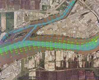
Interactive Data Server of Currents & Water Depths The Fraser River in British Columbia, Canada, is a river that is heavily used for transportation, and is also prone to extensive sedimentation. In order to aid in navigation, a pair of models were implemented to simulate currents and water levels in the lower 100 kilometers of the Fraser River for the Canadian Coast Guard. The one-dimensional model MIKE11 was used to model approximately 250 kilometers of channels in a region with a 5 meter tidal range and flows over 12000 cubic meters per second. This model was used to drive a two-dimensional model of the last 30 kilometers of the river using the finite element model TELEMAC-2D. These models are used for water depth forecasts to users of the river on a weekly basis. |
|
|
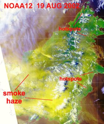
Baird & Associates undertook a large, multi-faceted investigation of the fire and haze episodes which occurred on the Island of Borneo in 1997 and 1998. The overall study involved an assessment of the haze episodes; the investigation and development of recommendations for use of public buildings and individual protection during haze episodes; and the development of capability within Sarawak to predict and monitor future haze outbreaks. A key element of the project was the creation of an Air Quality Mapping System (AQMS) designed to integrate critical information for decision making on a real-time basis, including remote sensing, within a GIS framework. The AQMS incorporated display of hot spots (potential fires) along with satellite imagery received on site, real-time air particulate measurements, the results of air parcel trajectory modeling and GIS information in Arc GIS format. |
|
|
Flood & Erosion Prediction System The Flood and Erosion Prediction System (FEPS) is a custom software application developed by Baird that links GIS functionality and engineering models in a modular system to evaluate coastal hazards. The system includes numerous modules to pre-process data and to provide information for numerical models. The FEPS generates, manages and presents data on a user specified reach basis, including nearshore wave climate, run-up and flooding levels, a regional sediment budget, erosion of sandy and cohesive shorelines, slope stability and estimates of long term shoreline position under various future lake level scenarios. The FEPS can be used for Coastal Zone Management and Regional Sand Management. |
|
|
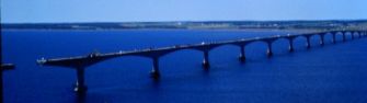
Baird was responsible for the assessment of scour potential, design of scour protection and development of a scour monitoring program for the $840M, 13 km long Confederation Bridge between New Brunswick and Prince Edward Island. The development of a near real-time wave and tide monitoring software system was an important component of the scour monitoring program. |
|
|
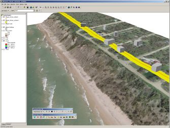
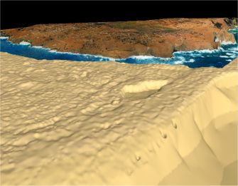
As part of the Barbados Coastal Infrastructure project, Baird has provided the Coastal Zone Management Unit with an extremely valuable tool for communicating complex coastal processes in a manner which everyone can understand. The results allow the CZMU to explore their LIDAR, bathymetry, aerial photograph and other data bases either individually or combined in many different manners. They can also automatically generate numerical model grids with optional matching aerial photos for wave analyses or create a 'fly-by" for public presentations and information sessions. This tool has already proven to be a very effective coastal engineering tool for assessing new sites or for communicating complex situations to the general public. |
|
|
Baird has produced comprehensive systems for managing and analyzing acoustic telemetry data received by tagged/implanted marine species. The Bio-Tracking software package has the ability to integrate a variety of complex dynamic datasets synchronized both temporally and spatially into the same environment. The package can perform detailed analyses, generate complete tracks using statistical methods to predict movements where data is missing, and present the data through high quality detailed animations. |
|
|
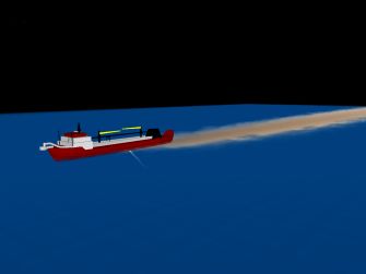
Dredging Sediment Plume Modeling The U.S. Department of the Interior Minerals Management Service is responsible for managing the sand resources on the U.S. outer continental shelf. One of the primary environmental concerns is the impact of suspended sediment and subsequent bed deposition generated by offshore dredging operations. This project involved the development of a comprehensive numerical tool, called the MMS Dredge Plume Model, that is capable of simulating the fate of the sediment plumes generated by Trailing Suction Hopper Dredgers (TSHD). Software development aspects of the project involved the creation of a model graphical user interface, and a 3D animation tool for viewing model results. |
|